
Anoxia, a complete lack of oxygen in the turf plant caused by prolonged periods of ice cover on some types of cool-season putting greens, is a major concern for golf course superintendents.
Imagine the benefits of knowing about threatening weather events long before they arrive.
Herb Stevens, a former TV meteorologist and one of the original on-air personalities when The Weather Channel debuted in 1982, has been providing weather reports to the skiing and golf turf industry for more than 20 years. His clients in the golf business say his mid- to long-range forecasts are more reliable than anything they can get anywhere else.
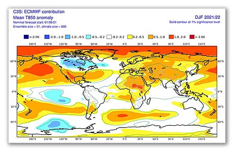
In a recent TurfNet webinar he presented with fellow meteorologist Garrett Bastardi, Stevens said superintendents in some areas of the country can expect colder-than-average temperatures and higher-than-normal amounts of precipitation that are common in a La Niña winter.
CLICK HERE TO LISTEN TO THIS AND ALL PAST TURFNET UNIVERSITY WEBINARS
"As we take a look at the next five months or so, you have to understand the main consideration is where the potential energy is wrapped up in the whole global machine of the weather. Oceans are where we look first," Stevens said.
"A La Niña usually results in a colder-than-normal winter for much of the country."
Stevens has been providing weather updates for superintendents under the Grassroots Weather badge and has teamed with Bastardi and others to recently launch the Turf Threat Tracker app that provides geo-specific short-term weather updates.
The weather event that scares me the most is the ice storm. . . . You tend to have dry winters in Florida. If you like to go to Florida during the winter time, La Niñas are a good time to go.
For the second straight year, the United States appears to be headed into a La Niña winter, which is triggered in part by cooler water in the Pacific Ocean according to Stevens and Bastardi.
Stevens explained that temperatures are colder than usual for much of the U.S. even in a weak La Niña year.
"There is a fair degree of variability during the course of a winter," Stevens said.
"If you get to moderate (La Niña), it changes things. You have a colder-than-normal winter for a good portion of the country."
There are differences between the La Niña predicted for the upcoming winter and the last one, including pockets of warm water off the coast of Alaska last year that kept precipitation amounts down. Those warm waters have been replaced by cooler waters this year signalling more chance of precipitation in the Midwest and Northeast, and increased chance for ice accumulation where cold and warm air masses meet. As warm moist air from the Gulf of Mexico sweeps north and meets a cold air mass, the result is snow, or worse, ice.
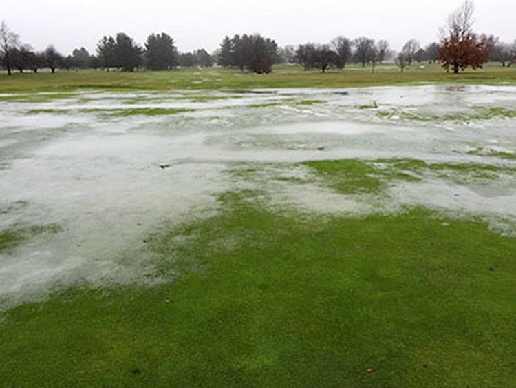 "The weather event that scares me the most is the ice storm," he said.
"You tend to have dry winters in Florida. If you like to go to Florida during the winter time, La Niñas are a good time to go."
It is no surprise that Stevens eventually brought his forecasting to the golf industry. An accomplished golfer, Stevens caddied on the PGA Tour from 1969-80, including five years for Larry Nelson. He once called caddying for Nelson during the 1979 Ryder Cup at The Greenbrier in West Virginia, his greatest golf memory. As a graduate of Penn State University's meteorology school, Stevens always believed it made sense to work with superintendents, given the school's well-known turfgrass program.
Most traditional forecasting services use information from the National Weather Service. But those forecasts only look at small windows of time. Stevens and Bastardi make their long-range forecasts from studying time-tested forecasting models that marry current conditions with information gleaned from examining similar weather patterns and cycles from the past.
Several European models that Stevens and Bastardi have studied point to a second straight La Niña winter.
"There's going to be a battle between the cold air that's going to want to push in due to the driving forces through the atmosphere along with the warmer that's farther south due to some of the La Niña impacts," Bastardi said.
"So what you're going to see is a lot of back and forth this upcoming winter. We think early on, everything is pointing toward a cool, fast start. But after we get past that cool, fast start to winter there is going to be some variance. And so when you look at these temperature anomalies at 5,000 feet above the surface it very much reflects what you see with the 500 millibar pattern: cooler across the northern plains, cooler than normal in Canada, warmer than normal across the South, and in turn, the stormiest weather you are going to see is right at the collision of those two air masses."
