
Can an airplane flying "low and slow," shooting high-resolution multi-spectral imagery, help with sustainable management of your golf course? Or perhaps assist you with laying out a new facility?
Steve Apfelbaum, founder and principal ecologist at Applied Ecological Services answers enthusiastically in the affirmative.
"Every day we realize more landscape management applications of the aerial imagery we can acquire with our defense-grade, high-resolution, multi-spectral camera. From airport wildlife hazard assessments to wildfire risk mapping in remote backcountry, to management and planning in cities, parks, and golf courses the possibilities keep multiplying," said Apfelbaum.
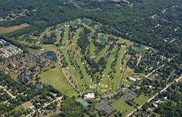
Much more than just pretty pictures, aerial images produced using this military-originated technology show fine enough resolution to detect objects as small as 9-12 inches in diameter, supporting precise on-the-ground measurements. On a golf course, for example, imagery can be used to keep tabs on spatially specific management concerns such as trespass or illegal dumping.
The "multi-spectral" aspect of the Leica RCD30 camera refers to the Red, Green, Blue and Near-Infrared spectral bands the camera is able to image. The near-infrared band allows the formation of spectral signatures, characterizing vegetation types (and other land surfaces) by how they uniquely reflect and absorb light. This information can also be correlated with such attributes as plant stress and health, seasonal growth phases, and long-term ecological changes, allowing a manager to remotely evaluate vegetation over large areas, such as golf courses, efficiently and cost effectively.
A fast turn-around is typical. An average 200-acre golf course can be flown in a half hour or less. Depending on the level of analysis needed, results can be made available quickly, within days to a couple weeks. Managers can then respond to emerging problems with alacrity, allowing operations to keep moving along smoothly to keep customers happy.
At the Medallion Club (a golf course near Columbus, Ohio), AES scientists used basic aerial imagery to detect places where fairway construction had inadvertently broken historic farm field drain tiles resulting in unwanted flooding and drainage of adjacent wetlands. The situation had burgeoned to a dispute with the U.S. EPA. Imagery was used to help resolve the dilemma and avoid potential fines for unplanned wetland damages.
In northern Illinois, failing historic agricultural drain tile lines were contributing to poorly drained conditions, failing lawns, and tree disease at a national historic site and adjacent golf course. Imagery was used to provide early detection and mapping of tree stress. Linked to on-the-ground identification of a fungal disease, the landscape managers of both facilities were able to take prompt corrective actions and forestall a greater calamity.
One Illinois golf course used imagery to detect lawn areas that were over or under-fertilized, allowing for better targeted applications of expensive fertilizers.
Encroachments of weedy invasive plant species were also mapped, again allowing grounds managers to selectively focus their use of herbicides. Such targeted chemical applications not only save money; they also cut down on potential contaminants in runoff.
Golf courses, like airports, attract their fair share of geese, gulls, and deer (and other wildlife), which, in turn pose problems in terms of droppings and damage to vegetation. A golf course owned by the University of Illinois, located adjacent the Universitys Willard Airport, was able to make imagery do double duty. The same imagery that helped the airport understand how to manage vegetation to minimize wildlife hazards was also used by their neighbor, the golf course. Together they are creating compatible and coordinated land management plans that minimize wildlife issues.
Aerial imagery can also be used to create accurate maps of the effects of rainstorms. A manager can use imagery to detect failing storm water sewers and drainage pipes, informing maintenance and repair activity. In a proactive application, imagery can be used to map erosion upstream and downstream of a golf course. These images, combined with strategic field measurements, can be used by a golf course manager to respond to water pollution accusations that may be leveled at them when pollution problems arise in the watershed.
Far more than just a striking framed aerial photo on the clubhouse wall, high-resolution aerial imagery makes sustainable golf course management both doable and affordable.
- Applied Ecological Services