
Whoever coined the phrase 'What you can't see can't hurt you,' most assuredly did not work in the golf business. The ground beneath the greens and fairways of golf courses everywhere are pocked with unseen obstacles, such as rocks, cables and wiring, pipe and cavities that can affect drainage and water-holding capabilities.
Ground-penetrating radar systems that can detect unseen obstacles are among the new tech toys forging their way into the golf market to help superintendents locate underground objects during restoration, construction or repair projects or even subsurface structural deficiencies that can affect everyday play.
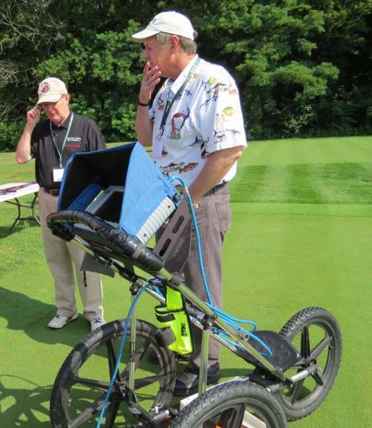
The U.S. Department of Agriculture has been testing the SIR 3000 from Geophysical Survey Systems to detect, among other things, bulk-water content beneath the surface of golf course putting greens at depths to 5 feet.
"Originally, our research focused on being able to map infrastructure at the base of the greens, particularly drainage systems, sand and gravel," said the USDA's Barry Allred, Ph.D., at last year's OSU Field Day. "Recently, we've been looking at it to map water content in the sand layer."
Subsite Electronics also is trying to break into the golf market.
The 2550GR from Subsite is a ground-penetrating radar system that can detect metallic and non-metallic pipes and wires at depths, the company says, of up to 19.7 feet, even when beneath rock. It is unlikely anyone in the golf business ever will have a need to test the upper limits of such claims.
Subsite's 2450 and 2550 models also can detect sinkholes and cavities that can affect not only drainage but player safety, as well as concrete and underground storage tanks.
New software for the 2550GR is designed to make users more efficient. Easy GPS connectivity allows operators to see their path and marks in real-time as they scan. A new wireless connection enables users to easily download web-based maps such as Google Earth.
These tools are no toys.
The Subsite GPR devices have a scanning width of nearly 20 inches and employ a dual-frequency antenna that allows the operator to view shallow and deep objects simultaneously on a GPS-connected monitor.
The GSS line can collect more than 8,000 samples per scan and can differentiate between sand, soil and gravel beneath the surface, and can measure and map bulk water content.
"It measures the values of depths at various locations, the spatial variation across the green, whether it is draining well or staying wet," said Allred.
Ground-penetrating radar, however, is not likely to replace hand-held soil monitors anytime soon due to their hefty price tag. The technology, according to the USDA, starts at about $25,000 per unit.