
 It has taken a pair of earth-orbiting satellites that are the result of a joint effort between an American university, a German space agency, an R&D arm of NASA and launched from a Russian cosmodrome to get a handle on the fate of groundwater in the United States and around the world.
From 310 miles above the surface of the earth, the Gravity Recovery and Climate Experiment satellites (known as GRACE), can calculate the amount of groundwater lost over time by measuring changes or anomalies in the earth's gravitational field. And the information those satellites are sending back to earth is disturbing.
Launched in 2002 from the Plesetsk Cosmodrome on the shores of the Arctic Ocean, the GRACE satellite project is a true global collaborative effort between the University of Texas Center for Space Research, NASA, the German space agency DLR and Germany's National Research Center for Geosciences known as GFZ. Daily operations and data collection are conducted by NASA's Jet Propulsion Lab in Southern California.
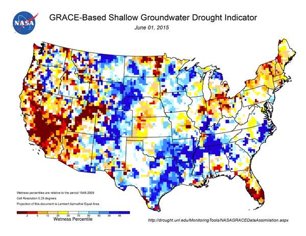
The two satellites, which were built in Germany, orbit the earth 137 miles apart, and take measurements of gravitational changes in the area between them. The data are converted into usable maps, with yellows, reds and browns indicating dry conditions and blues indicate wet conditions.
Information sent back from those satellites shows that groundwater supplies beneath parts of the United States, notably California, other parts of the American West and Florida, are being depleted at alarming rates. And if those areas are ever to be replenished, it will require water in almost-unimaginable volumes to do so.
Variations in the earth's gravitational field can be caused by many factors, including how much water is stored underground, in the rootzone and at the surface. And the GRACE system is able to see all of that.
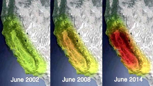
In December, NASA imagery revealed that more than 11 trillion gallons had been lost from 2011-14 from California's Sacramento-San Joaquin River Delta, the largest estuary on the West Coast of the United States. That volume of water, says NASA, is more than the state's nearly 38.8 million residents use each year for non-agricultural purposes. The delta, which empties in San Francisco Bay, is steadily losing about 4 trillion gallons per year, according to NASA.
The space administration also says about two-thirds of those losses are due to groundwater pumping in the state's Central Valley. Occupying 22,000 square miles, the Central Valley represents about 1 percent of the country's agricultural land, but produces nearly 10 percent of the country's food supply.
It will require a water windfall equivalent in volume to Lake Mead (the country's largest reservoir), to replenish what has been lost in the delta.
NASA doesn't just measure groundwater storage beneath California. It has been monitoring it around the globe, and California isn't the only place where a lack of groundwater exists.
Predictably, other parts of the west, notably much of Arizona, Nevada and Utah are facing groundwater deficits, as are parts of the Midwest and the Northeast. Even much of Florida, most of which receives 50-60 inches of rain per year, is lacking sufficient groundwater supplies.
The same technology that shed light on the groundwater supply underneath the surface in California also has revealed that from 2004 to 2013, about 17 trillion gallons had been lost in the Colorado River basin, a major source of water for tens of millions of people in seven states, including places like Las Vegas, Phoenix and Southern California. Some 13 trillion gallons of that total was lost groundwater, according to NASA.
In 2014, PBS published a story citing GRACE data on the relentless draws from the massive Ogallala aquifer that supplies water to parts of Colorado, Kansas, Nebraska, New Mexico, Oklahoma, South Dakota, Texas and Wyoming. The story indicated that over the previous 10 years the aquifer had been depleted by a volume equal to Lake Tahoe. Many of the states pulling from the aquifer have been in some stage of drought in recent years, including Texas, where officials say they have been pulling water from the Ogallala at a rate six times greater than what is going in.
In response to information provided by the GRACE system, California Gov. Jerry Brown in 2014 signed into law the Sustainable Groundwater Management Act, multifaceted legislation that requires water agencies to develop plans to ensure long-term protection of the state's groundwater resources.
Since the advent of the GRACE system, the Florida Department of Environmental Protection in 2012 enacted its own Ground Water Management Plan designed to protect the state's underwater springs, surface water impoundments and provide a foundation to help regulate agricultural practices that use these resources.
The hope, of course, is that the GRACE system provides enough information that groundwater supplies can be protect rather than depleted further. In the past, protecting groundwater has been a difficult endeavor, because measuring what is in the ground has been difficult and unreliable.
Until now.
This is part of a multi-part series on golf and water in California.